About me: I am Marcus butler
My name is Marcus Butler. I am a student at Portland State University. In fall of 2022 I earned credits for assisting in the environmental field and lab work of Tris Kibbey’s masters thesis project in Dr. Jen Morse Biogeochemistry lab. Tris’ project was looking at how soil, gas, and water was being affected by the application of treated water from the utility Clean Water Services. Clean Water Services is a public water resources management utility in Washington county Oregon. It was in assisting with this project in my coursework with Tris and Professor Morse that I met John Goetz, an environmental project manager at Clean Water Services.
Jen connected me with John who connected me with Randy Lawernce for my senior capstone project. John and Randy are managing a Clean Water Services’ project named the Climate Adapted Plant Materials. This is not a project you will find on the Clean Water Services website, although rate payers in Washington county are contributing to this project since it is in active research, development, and implementation. I think that is important to note, the public funds this project in some capacity.
Jen connected me with John who connected me with Randy Lawernce for my senior capstone project. John and Randy are managing a Clean Water Services’ project named the Climate Adapted Plant Materials. This is not a project you will find on the Clean Water Services website, although rate payers in Washington county are contributing to this project since it is in active research, development, and implementation. I think that is important to note, the public funds this project in some capacity.
Clean Water Services (CWS) is a water resource utility company that is finding purposes for reusing water. You can check out CWS company history on their website here or using the button above.. CWS currently operates four wastewater treatment facilities (CWS calls them water resource recovery facilities) to serve its large and growing customer volume of over 600,000 people. They take customers' used water and put it through their facilities to generate renewable energy, biosolids, fertilizer, and clean drinkable water. They take customers money and water to generate jobs, clean water to release into the Tualatin river (being very careful to comply with their federal permits detailing the process to not significantly change the temperature and composition of the Tualatin river when releasing treated water into the river), restore habitat lands along over 157 miles of stream river banks, acquire more data to aid in project management, issue site permits, allow students and volunteers to participate in field programs, and create new perceptions on natural resource management.
Climate Adapted Plant Materials Project (CAPMP): What is it and why is it important?
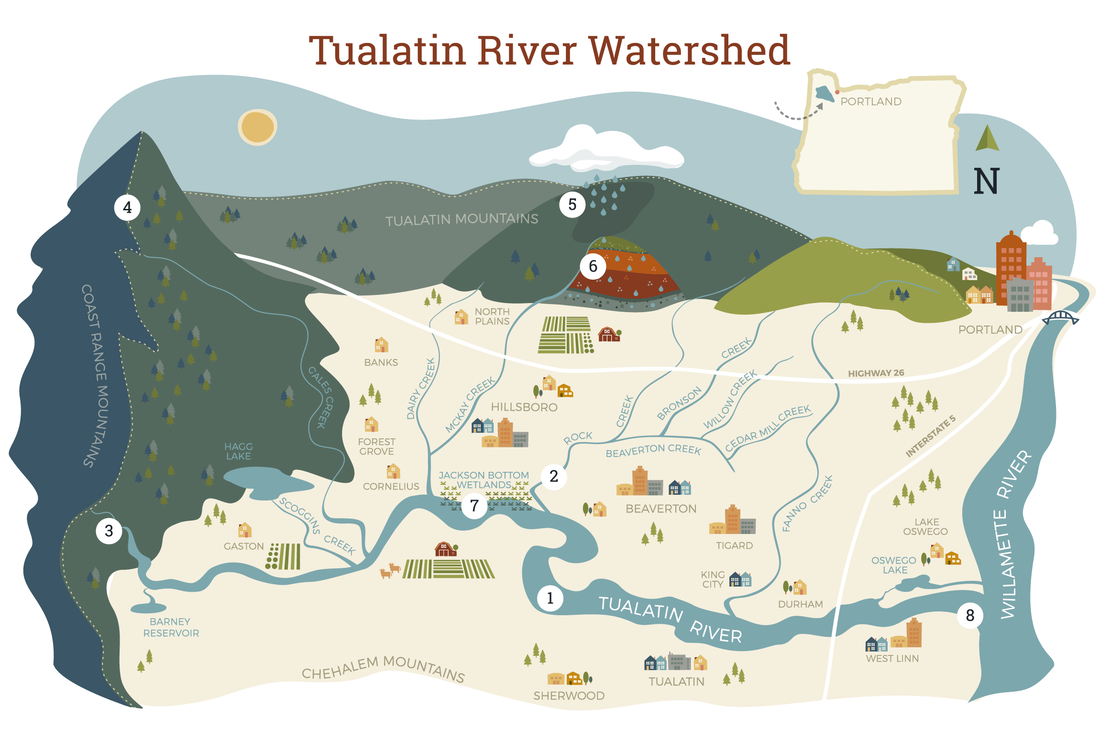
CWS has a department that focuses on building partnerships and implementing collaborative conservation strategies for watershed ecological improvement, this project is practicing that. A watershed is a land area that channels rainfall and snowmelt to creeks, streams, and rivers, and eventually to outflow points such as reservoirs, bays, and the ocean. (NOAA 2023). In the past, collaborative efforts to conserve natural resources in the Tualatin Basin have used locally sourced plant materials to accomplish different habit enhancement and water quality goals. The CAPM is a collaborative effort by CWS and the Tualatin Soil and Water Conservation District (TSWCD) to bring in non-locally sourced plant materials. It is a pretty straight forward concept, but the science behind the decision making is detailed and assumptions must be made. Below are the details of the concept for the CAPMP.
In summary, the project aims at utilizing a reference site (the Tualatin Basin) as a place for planting plant species from a future climate analog site (Northern California) due to the concept that the analog site contains plant species that exist in climatic conditions that do not exist currently in the reference site but these conditions are predicted/modeled to exist there in the future. The expectation is that the species brought from the analog site to the reference site will be better adapted to the future climate conditions that are being predicted/modeled in the reference site. A very in the future project, no doubt about it.
Developing guidance: My involvement in the CAPMP
The CAPM has many project phases and began in 2020. My community partners at CWS shared with me a technical report that they had contracted from an environmental consulting company that detailed the relative abundance data of plant communities from the climate analog sites. My task was to use the data from the technical report to take a deeper look at existing resources to help validate what they had discovered in the climate analog region. I choose to narrow my focus since the scope of this project is very large and covers many plant communities from the analog climate sites.
My draft guidance on climate adapted plant sourcing I provided to CWS is below.
My draft guidance on climate adapted plant sourcing I provided to CWS is below.
| cnps_s4g4_wet.xlsx |
| cnps_s5g5_wet.xlsx |
Here is how I did it: Plan of action
I knew after meeting with community partners that my work in the CAPM is important because the list of species generated with their respective relative abundance information will help guide the determination of what plant materials will be planted by CWS and TSWCD in the Tualatin Basin and at what frequency. I knew also that for me to contribute to CWS unmet needs expressed to me, I would need to do diligent research to make sure the information I found is sourced from plant surveys in this specific area shown on this map.
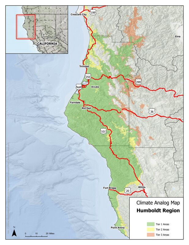
Specifically the relative abundance information Randy and John were looking for was stem counts of species from Riparian forests and the percent of land cover the species covered from the areas surveyed. The good part of researching for this information is that it is relatively specific, so I know what it is I am looking for. The difficult part of researching this information is that it is so specific that it is difficult to know where the information would be published and who would be the group of people who created it. My community partners recommended I look for this information in plant surveys, published literature, National Vegetation Classification Standard, California Native Plant Society, the United State Forest Service, and the Bureau of Land Management. My goal was to find stem counts of species from Riparian forests in the area shown on the map above and the percent of canopy cover the species covered from the area surveyed as well the respective scientific species names.
I looked for said specific information on the internet at large. This multi-week search over the Winter term contained google searches and google scholar searches on relative abundance data from existing publications of plant surveys. When that was unsuccessful I went to my list of sources and continued looking for the information which resulted in the two files above containing species identified by the California Native Plant Society.
I looked for said specific information on the internet at large. This multi-week search over the Winter term contained google searches and google scholar searches on relative abundance data from existing publications of plant surveys. When that was unsuccessful I went to my list of sources and continued looking for the information which resulted in the two files above containing species identified by the California Native Plant Society.
REFLECTION OF MY WORK WITH CWS:
In my involvement with developing guidance in this project, I collaborated with project managers Randy and John at CWS to help collect data to validate the information CWS had already gathered from sites with future climatic conditions (Analogue Site) similar to the Tualatin Basin (Reference Site) where CWS and the Tualatin Soil and Water Conservation District will be conducting ecological restoration. My goal was to focus on the plant communities from the Riparian Forest in the Humboldt region. I ended up with species from a variety of habitats in the Humboldt region and beyond. I used the USDA wetland indicator tool to relate each species to the water and soil characteristics of riparian plant communities.
During working on this project I realized many times I often do many things throughout the day I take for granted. I am lucky to be involved in an environmental plan like this. Regardless of the impact of my contribution on the overall outcome of the project, I know I can say I am grateful for the opportunity to work on such a in the future project. It is from working with my community partners that I got inspiration to continue on my learning journey in the environmental work field and to work hard at becoming an environmental manager.